The Outer Hebrides (now called the Western Isles) from Top to Bottom - Part 3 of 3 The Isles of North Uist, Benbecula, South Uist and Barra |
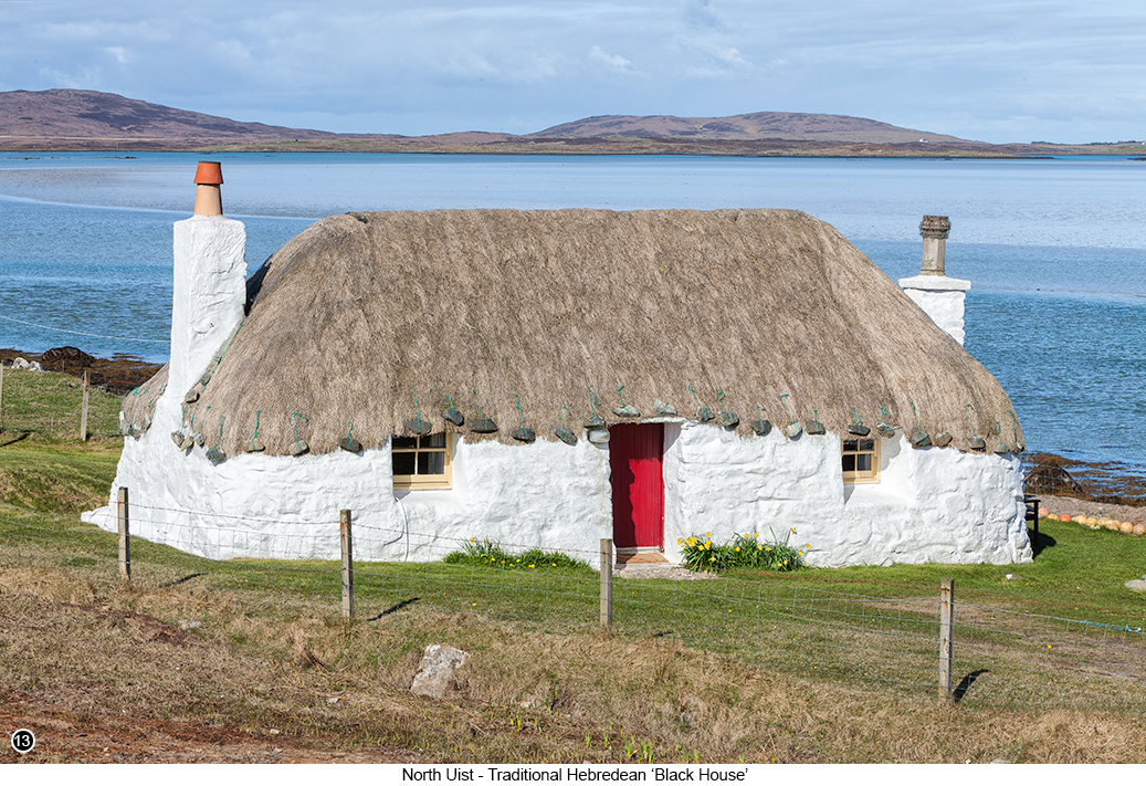
Once you land on North Uist at the Berneray ferry terminal Street View, Map View, drive out of the village on the B893 and then about a mile or so later, you will see a 'T' junction with the B8665. So take a right turn here and then head South towards the tiny hamlet of Sollas, Street View, Map View and a very pleasant 30 minute drive alongside the coastline on your right. Until you reach the view of a traditional Hebridean stone 'Black House', but which is now being called the 'Truman Cottage' and which is also available to rent I believe, as shown below in SHOT 13, Street View, Map View. So I imagine you are looking at the picture below and thinking to yourself, "why would it be called a 'Black House' if it is White?" Well there is some debate about this, but the modern thinking is that in the local and ancient dialect of Hebridean Gaelic (which is still widely spoken on the islands), when it was first encountered by early English travellers several hundred years ago, that they began to interpret and translate the ancient Gaelic tongue into English phonetically and which of course led to many mistakes and misinterpretations. So that the Gaelic word of "tughadh" meaning "Thatch", became incorrectly translated as "dubh" meaning "Black". Now "tughadh" and "dubh" look like two entirely different words when written down side by side don't they? But the way Gaelic is spoken (and rarely written down by the way), along with all its variations of dialect across the entire length of Scotland, Ireland and even some parts of Wales, means that some letters evolved to have different sounds and meanings, depending on where they appear within a word. So a "dh" within a word is pronounced as a "y" and has an entirely different meaning and pronunciation than if it appears at the beginning or the end of a word - but my Gaelic is very limited indeed and so I do not pretend to be in any way knowledgeable about this subject, other than to say, that when the words "dubh"and "tughadh" are spoken by a fluent Gaelic speaker, to a none Gaelic speaker such as myself, then both words to my untrained ear will sound pretty much exactly the same. There are other theories of course, such as the original design of these small houses not having any chimneys and instead the thick black smoke from the central peat fire, would just be allowed to waft up through the thatch so that it warmed up the rest of the house, but at the same time turning everything as black as the peat they were burning. And which probably also had the side benefit, of keeping the dreaded Scottish midges at bay throughout the summer months, because they will always shy away from the smell of smoke. But for whichever reason this inverse of black and white took place here in Scotland, it is at least good to know that after seeing these types of dwellings across the islands (and there are quite a few of them), you can feel confident that the next time you find yourself leaning against the pub bar, at the end of an evening spent listening to the local 'know-it-all', that you can now legitimately and truthfully argue with him, that black is indeed white and even show him the pictures to prove it... |
|
|
|
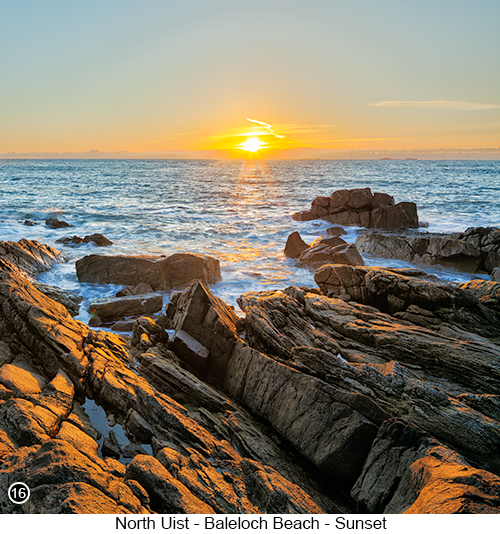
Then after taking your shots of the 'Black House' as shown above, continue driving South on the B893 until it meets up with the A865 and then continue driving on for another 30 miles or so towards our next destination, which is the tiny sandy cove at Baleloch, but which has some small but amazing rock structures hidden away within it and which also happens to be a great location for a sunset shoot. Although as I now look at SHOT 16 below right, I can now see how I really haven't done this location justice. But my excuse for this so-so shot, is that I was only there for one evening and this was the best I could do, so I will have to go back and try to get something better. |
 |
 |
|
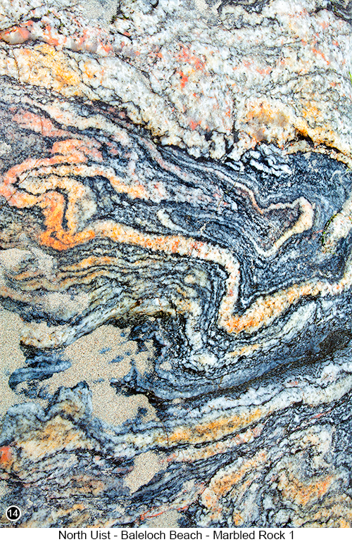
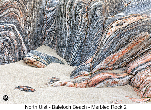
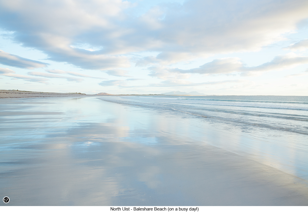
About 30 miles below Sollas on the A865, you will eventually come to sign for the village of Hosta pointing to your left and a gate across a sandy track to your right, Street View, Map View, with a Parking and Picnicking sign that points through the gate to the land on the other side. So take this right turn and go through the gate - and of course make sure you lock the gate securely again after you have driven through it, to stop any of the sheep or cattle from wandering out in to the road and causing an accident, or getting squished. So after driving through the gate, follow the sandy track as it arcs over to your right and park anywhere you can on the field nearest to the burn (stream). If you then walk down to the edge of the small burn towards your front right, you will see what is left of a small dilapidated bridge, which when I was last there, still had part of the old rickety bridge that I could wobble across. But it wasn't very safe and most of it had already collapsed into the burn or been washed away, so by the time you get here, the bridge may well be gone altogether. But you should still be able to easily jump across the stream if you follow it down and around to your left, to where it widens out and becomes a lot more shallow, as it flows out over the beach. Once on the beach at low tide (which is the best time to be here), you will see the rocks over on your right that contain these multi coloured marbled strata, as shown in SHOTS 14 and 15 above. It was raining gently when I took these shots, so the rocks were wet and which definitely helped to bring out all the colours. Also if you look up behind the rocks to the front right of the beach, you will see a fence with a hole in it and a path that leads up the side of the hill and then around the headland for a little way, to a really good view of some large rocky outcrops that point out to sea. Now even though I have already admitted that my SHOT 16 shown above doesn't really do this view justice, it is still a great location for a sunset shoot, with the waves breaking onto the rocks all around where you are standing, as the sun sets directly into the sea in front of you. Once having taken your shots of the coloured marbled rock formations and a view of the sunset that is probably a whole lot better than mine, return to your vehicle and get back onto the main A865. Because I am now going to take you to another tiny hamlet called Baleshare and a wide sweeping beach, that sits just behind a few nearby houses and which when we there, looked windswept and desolate, yet utterly beautiful at the same time and where we soon began to wonder, if no one but the two of us had ever walked across it before. This whole area is amazing and a great place for photography and hiking, with the peaks of a few low lying mountains poking up just above the distant horizon, as shown in SHOT 17 below. So continuing on from the bay at Baleloch and the multi-coloured rock formations etc., get back onto the A865 and continue driving South for another 12 miles or so, until you see a right hand turn signposted to Cladach a Bhaile Shear (Baleshare) and turn right here, Street View, Map View. Then continue on driving along this unnamed road for another 3 miles, until you see a dusty track heading off to your left and which will eventually lead you, to quite a large official car parking area at the end of it next to the beach, but that very few people seem to know about or visit Street View, Map View. Then once you are parked , walk down the short path near to the front right of the parking area and down onto the beach, for the view shown below in SHOT 17. Now the reason I have called this shot "North Uist - Baleshare Beach - on a busy day!", is because we spent two full days in this area, with at least 8 hours spread across the two separate days, both walking and photographing along this beach and we never saw another living soul. That is until about an hour before the sunset began on the second day, when an elderly gentleman dressed in the local tweed and a with well worn deerstalker hat perched on his head and walking with a stick made out of some sort of twirly looking wood (I know, you couldn't make this stuff up could you and I can't for the life of me think why I didn't swing around and take a photograph of him?) passed around the back of where I was setup, waiting for the colour to start happening in the sky. I turned around to say hello and smile cheerily at him (as you do) and in a grumbling voice he replied "Och it's busy on here today". Which I suppose could have been sarcasm, but it didn't sound like it to me and there was absolutely no one other than the three of us here, at least for as far as the eye could see in every direction and it been that way all the time we had been there??? In fact I am now going to digress for a minute, because this strange encounter with the grumbly old man, reminds me of another old dear that once walked past me, when I was shooting a sunset at a different viewpoint above the village of Plockton, near to where I live on Skye - and which I take you to in Chapter 59 starting on page 186 of my Guide Book. When this old lady, which I am guessing must have been getting up towards 90 and I am not exaggerating here, as she really was quite elderly, walked briskly past me in silence at the top of the viewpoint where I was setup and then headed off towards the front left edge of the rocky outcrop at speed and then further on through some bushes. Now to get up to the top of this rocky outcrop is only a relatively short hike, but at the same time it is still quite a steep scramble and which had both me and the missus huffing and puffing as we got to the top. So after the old lady had disappeared through the bushes and my brain had time to register what was happening and what I was seeing, I thought to myself, how did a frail old lady of such advanced years get up here in the first place and where she was going? Because there isn't a path passed where I was standing, only waterlogged rough ground. So off I went sploshing through the mud after her and to find out where she was heading to on the other side of the bushes and yes you've guessed it, there was no one there - cue creepy music... Anyhoo, back to the photography.. |
|
 |
|
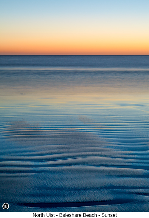
The image shown above in SHOT 17, was taken looking North just after we had walked down onto the beach from the car park and shows you how completely deserted this beach at Baleshare looks and how you can walk for mile after mile along what appears to be a pristine environment. So I would advise that if you do intend to walk for miles along this beach and stay here for several hours waiting for the sun to set as we did, that you also bring along your own food and refreshments, as there are absolutely no facilities or shops here, so whatever you need, you will have to bring along with you - but what a place for a picnic? SHOT 18 shown on the right, was taken around 30 to 45 minutes after the sun had set the following day. There was almost no light left in the sky, but I knew (hoped) by using a very long exposure, that the camera’s sensor would still be able to pickup the afterglow and colours in the sky that my eyes could no longer see. It was also a gin clear sky and is the reason why the wet sand in the foreground looks so dark, because it is reflecting what remained of the light, in the the dark blue but clear starry night sky above me. Now of all the photographs I have ever taken across the Western Isles (Outer Hebrides), this image on the right is probably the one I most enjoyed, as it brings back many pleasant memories of our visit to the Islands and even though it looks like an abstract, it isn't and is in fact a fairly straight long exposure shot and the nearest thing to night photography I have ever done and I as I look at it now, it makes me want to go back and do it all over again. It is also worth noting, that it was so dark by the time I took this shot, I couldn't see anything through the viewfinder and as the tide was now receding at quite a pace, if I wanted to use what remained of the light in the sky directly above me, reflected across the sand lines in the foreground in front of me, I could only take the shot when the sand was still wet. Which meant I was having to constantly shuffle my kit forward, to get it just beyond the highest point where the previous wave had reached and all before the sand had time to dry out. Which meant that I was continually having to re-set my hyperfocal distance point for a third of the way into the shot using Live View, which would have been virtually impossible without my trusty head torch, that I was hand holding and using to light up the foreground, so I could manually lock my focus onto what it was illuminating, before turning it off again just as I hit the shutter release button on my remote. So there I was shuffling around with my head torch in one hand and my tripod and remote in the other, as I kept advancing beyond the movement of the tide, as well as trying to use my large golfing type umbrella, to shield the camera from a blustery wind that had begun to blow in from my right. So as I only have two hands and they were both already full, I asked my dear long suffering wife to help me out, by holding the brolly next to the camera. I then got her to lower the brolly into the horizontal position and pulled her in as close towards me and my kit as I could, to block out the wind - and yes we had a quick snog under the stars, I mean it doesn't really get anymore romantic than this does it?. And which meant that she then became my mobile windshield, that I knew would automatically track along with me, as I kept shuffling further towards the sea and where the sand was still wet. So when you look at this image on the right, I bet you think it looks all tranquil and serene don't you? But I can honestly say that when I was taking it, there were moments when it felt like we had turned into a couple of clowns, performing a badly scripted slapstick routine at the circus. |
 |
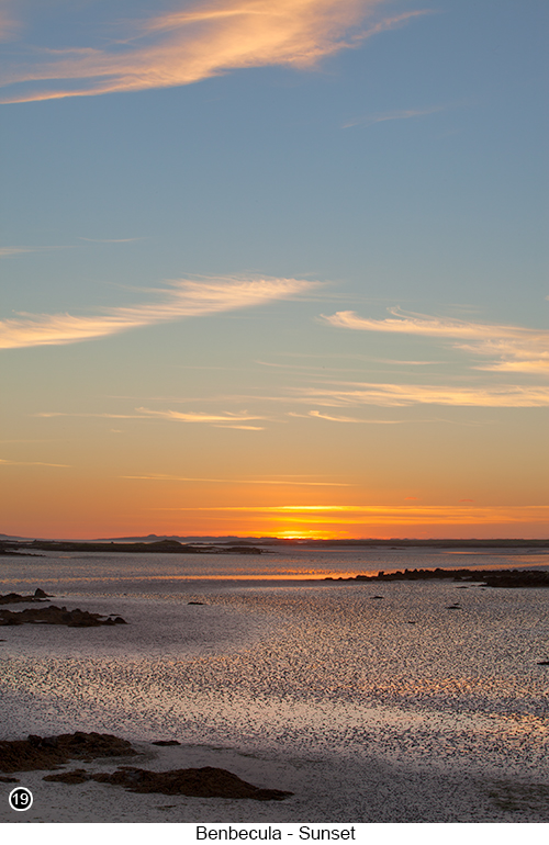 |
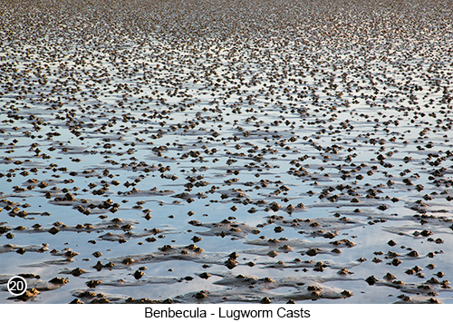
Moving on from North Uist and the beach at Baleshare, if you get back onto the main A865 and continue driving South for another 6 miles, you will eventually come to a long causeway that connects the Island of North Uist to the Island of Benbecula. But before you drive across the causeway, at the beginning of it there is a small parking area on your right Street View, Map View, where you can safely park your vehicle and then walk up onto a small hump of land next to the road, for the views shown in SHOTS 19 to the left and 20 below. SHOTS 19 and 20, shows you just how abundant the food is available to wildlife on the Outer Hebrides and is why such a huge variety of birds and other wild animals are attracted, to the many mud flats that surround Benbecula and why this island has become such a wildlife watchers' paradise. Benbecula is an island within an island and is more like a huge stepping stone or a land bridge, that now joins North Uist and South Uist together, with Benbecula sitting in between. These islands all used to be separate until relatively recently, but starting in the 70’s and then on through the 80’s, the Highland Council undertook an extensive road and causeway building program, to join as many of the Hebridean islands together as they could. I think it is also worth mentioning here, that the island of Benbecula was once described by a globally famous company, that produces thousands of guide books of international renown and which says in its guide for travellers to the Highlands and Islands, that Benbecula is and I quote ‘Flat and Boring’. Well yes it is flat compared to the many mountains and peaks that can be seen on other nearby islands, but for wildlife watchers and photographers, I think Benbecula is anything but boring.
|
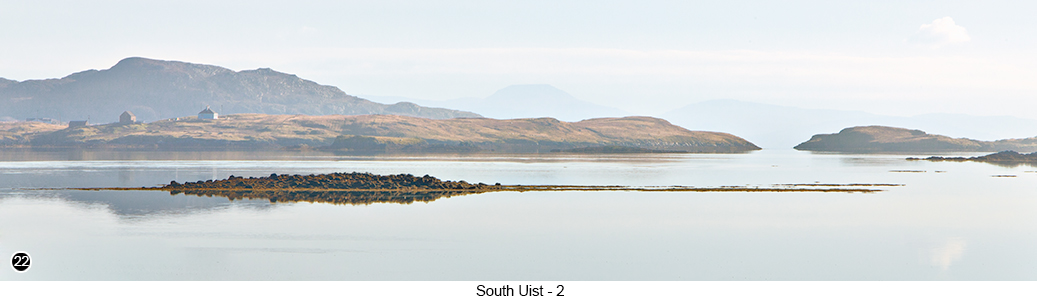
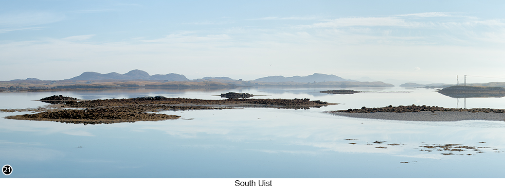
| After taking your shots on Benbecula, carry on driving further South, as you continue to follow the main A865 all the way down to the bottom of the island and the causeway that links Benbecula to South Uist. Then then just over the other side of the causeway, Street View, Map View, you will see a wide view from beside the road, that looks back across a large sea loch and then further back towards the Southern tip of Benbecula. This stretch of water becomes dotted with small, low lying islands at mid tide, as can be seen in SHOTS 21 and 22 below, but which then looks more like SHOT 19 at low tide and open sea at high tide. | |
 |
|
| Both these shots 20 and 21 shown above and below, were taken from the exact same viewpoint, as I was standing right beside of the road. It was a calm and slightly hazy morning at the beginning of autumn and the whole area seemed to be oozing with a feeling of calmness and quiet tranquility and which I then tried to capture the essence of when I was taking both of these shots. Now I know it is difficult trying to get your head around the idea of capturing your emotions in a photograph and is a subject I have also discussed in my book. So the quickest way I can explain this idea (or would that be better described as a concept?) is to describe it in the following way: Firstly when you next find yourself stood in front of a scene that you want to photograph, instead of rushing about and setting up your camera and concentrating on what settings you are going to use etc., just take a few extra moments to briefly and quietly study the scene and think to yourself, why do I want to photograph it and what is it about the scene that makes it so appealing to me right at this very moment? Because once you can answer the question Why, it should then be much easier to answer the question How? So as I said above, I found this view to be calm and tranquil, so then all I had to do was to try and take an image that looked as calm and tranquil as I felt. OK, I know I am now suggesting to you that this idea/concept of trying to capture your emotions in your work. as being something that is easy to do and it isn't at all, and especially when you are just starting out. But it will be once you get used to doing it over and over again and will even become second nature to you and something you can do without thinking about it. So why not try this idea for yourself next time you are out, hunting for that award winning shot and try to put a little of what you are feeling into what you are capturing, because it really can work wonders to improve the quality of your work, as well as massively contribute to the overall enjoyment of just being there. | |
|
|
| Then carry on driving South down through the Isle of South Uist, as you continue to follow the A865 for another 7 miles or so, until you see a left hand turn off to Loch a Charnan and turn left here, then continue on until you see a left turn to Rubha Ghaisinis and the Oransay Hotel (which is the hotel where we stayed for a couple of days - good, old fashioned place and who served us with a huge, full, gut busting Scottish breakfast every morning. | |
|
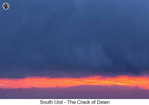
Now even though I am going to take you to the exact location where I took SHOT 23 shown here on the left, Street View, Map View. I must also warn you that this location isn't very photogenic, but just happened to be near to were we staying and I just got very lucky - although isn't there an old saying in landscape photography that goes something like: "Luck favours the prepared". But anyway, we had been on holiday for several days by this point and I was in full-on photography mode, where I was mentally putting a frame around everything I looked at. So early one morning before the sun rose, I was already out hunting for images, even though it was a very dark overcast sky and there seemed little chance of getting anything worthwhile. I wandered around for a while, with a look on my face that was getting longer an longer, until I noticed a sea fret had started to form just off shore and begin rolling in towards me, but that still didn't look like it would give me anything I could shoot. Yet as I watched it forming, I began to notice that a small sliver of dawn light had also started to appear between the sea fret and the storm clouds above it, as there must have been a temperature difference between them or something and which had enough force to start slowly pushing them apart. OK I will admit it, this shot was born out of sheer luck and I just happened to be in the right place at the right time, but hey, what's wrong with that? So I suppose the moral to this tale, is never give up however bad it looks, because nature can always do something in the blink of an eye, that will totally blow your mind and even when you think you have seen it all, nature will occasionally decide to do something amazing, to show us that we haven't even begun to scratch the surface. |
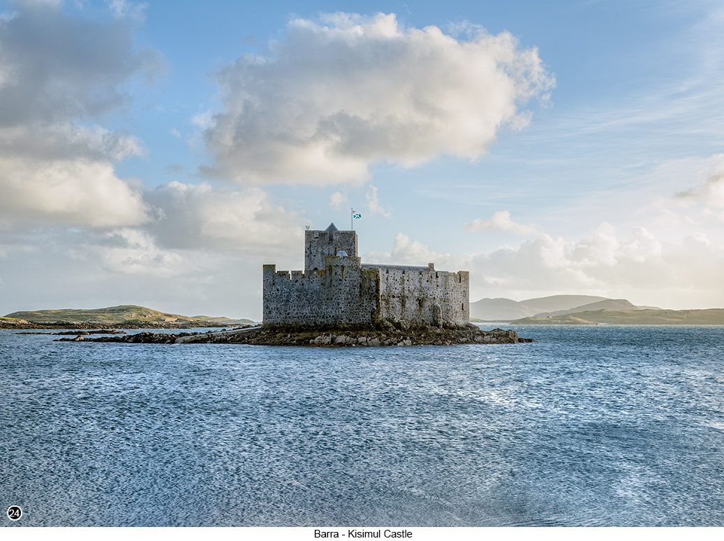
Then continuing on from the Isle of South Uist, I am now going to take you over to the final destination in my whirlwind tour of the Outer Hebrides and the tiny island of Barra. So carry on driving all the way South to the very end of the A865 and the tiny ferry terminal at Lochboisdale Street View, Map View. Where you can now board a ferry at Lochboisdale, for the very pleasant short hop over to the Island of Barra and which when it arrives on Barra about 30 minutes later, disembarks at Castle Bay, to a view of the tiny but very romantic Kisimul Castle, as shown in SHOT 24 below. I believe the name "Kisimul" is pronounced as 'Kissy-Mule' by most of the locals by the way, or at least that is the way it was being pronounced in the hotel we were staying at that overlooked the bay. |
|
 |
|
Barra is a tiny island of only 22 miles in length and which you can easily drive all the way around in less than two hours, but beautiful none the less and is why most visitors to the island, choose to explore it on hired bicycles. So after cycling your way around the entire island and taking your shots of Kisimul Castle etc., if you think you might also enjoy spending a couple of hours wandering around a large and very peaceful beach location covered in cockle shells, as you then watch the only commercial flight in the world, where the plane has to land directly onto the beach, then head over to Cockleshell Beach Street View, Map View around mid morning. But to give you a better flavour of what you will see at Cockleshell beach, I have linked to a short video here, that tells you a lot more about Cockleshell Beach and how it is also used as an Airport. |
|
--Exif information for each of the numbered shots shown throughout this chapter --13 - Canon EF70-200/2.8L IS USM, 1/90th Sec, f/16, ISO 100, Focal Length 80mm, taken on 21st Apr at 10:25 --15 - Canon EF70-200/2.8L IS USM, 1/45th Sec, f/22, ISO 100, Focal Length 148mm, taken on 19th Apr at 11:43 --16 - Canon TS-E24mm f/3.5L II, 1/10th Sec (-/+2 bracket), f/11, ISO 100, Focal Length 24mm, taken on 19th Apr at 20:37 --17 - Canon EF24-105 f/4.0L IS USM, 1/4 Sec, f/20, ISO 100, Focal Length 24mm, taken on 13th Oct at 17:41 --18 - Canon EF24-105 f/4.0L IS USM, 30 Sec, f/16, ISO 200, Focal Length 84mm, taken on 12th Oct at 19:21 --20 - Canon EF24-105 f/4.0L USM, 1/10th Sec (-/+2 bracket), f/22, ISO 100, Focal Length 105mm, taken on 10th Oct at 18:28 --21 - Canon EF70-200/2.8L IS USM, 1/100th Sec, f/16, ISO 100, Focal Length 98mm (4 shot horizontal pano), taken on 22nd Oct at 10:38 --22 - Canon EF70-200/2.8L IS USM + 1.4x, 1/30th Sec (-/+2 bracket), f/16, ISO 100, Focal Length 230mm, taken on 22nd Oct at 10:56 --23 - Canon EF70-200/2.8L IS USM, 1 Sec, f/16, ISO 200, Focal Length 200mm, taken on 20th Oct at 07:55 --24 - Canon EF24-105 f/4.0L USM, 1/80th Sec (-/+2 bracket), f/11, ISO 100, Focal Length 45mm (2 shot vertical pano), taken on 8th Oct at 17:38 |
|
If you have enjoyed reading these 'Extra' chapters to my Guide Book and think you might also enjoy reading 79 more chapters across 270 pages, that also includes more than 340 Fine Art quality images, along with detailed descriptions and large scale maps to guide you to the exact location of where I took each and every one of them and which then goes onto discuss the techniques and tools I used to process them, but where everything is written in plain easy to understand English? Then please consider buying the Book. |
|